-
 A new weather balloon initiative at Indiana University is helping improve local and national forecasts.
 -
 The average winter temperature has gone up about five degrees for almost every Indiana city studied since 1970.
 -
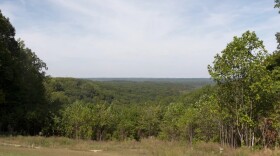 With the recent warm and dry weather, expect to see peak foliage nearly a week later than usual this year.
 -
 The National Weather Service forecast calls for the high potential of six or more inches of snow beginning Sunday morning.
 -
 The steamiest conditions on Friday were expected in parts of Ohio and Indiana, where heat indexes were expected to soar past 100 degrees Fahrenheit and remain there most of the day.
 -
 There's still some time for forecasts to change, but meteorologists predict that eclipse day storms could blanket parts of the path, which stretches from Mexico and Texas through Maine and parts of Canada.
 -
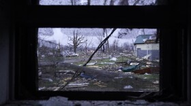 This winter's record warmth provided the key ingredient for a Midwest outbreak of deadly tornadoes and damaging gorilla hail that hit parts of the Midwest Wednesday and Thursday, tornado experts said.
 -
 Climate change isn't playing out everywhere in the same way. That's because our climate here in Indiana is different from other parts of the country and the world. This can make the data confusing. A member of our audience from Noblesville wanted to better understand it.
 -
 The heat bubble from the Southwest is making its way to Northeast Indiana, causing temperatures to rise to dangerous levels. The National Weather Service urged caution when going outside.
 -
 Unrelenting tornadoes that tore through parts of the South and Midwest have killed at least 11 people.

© 2026 | Privacy Policy
Play Live Radio
Next Up:
0:00
0:00
Available On Air Stations


