 DONATE


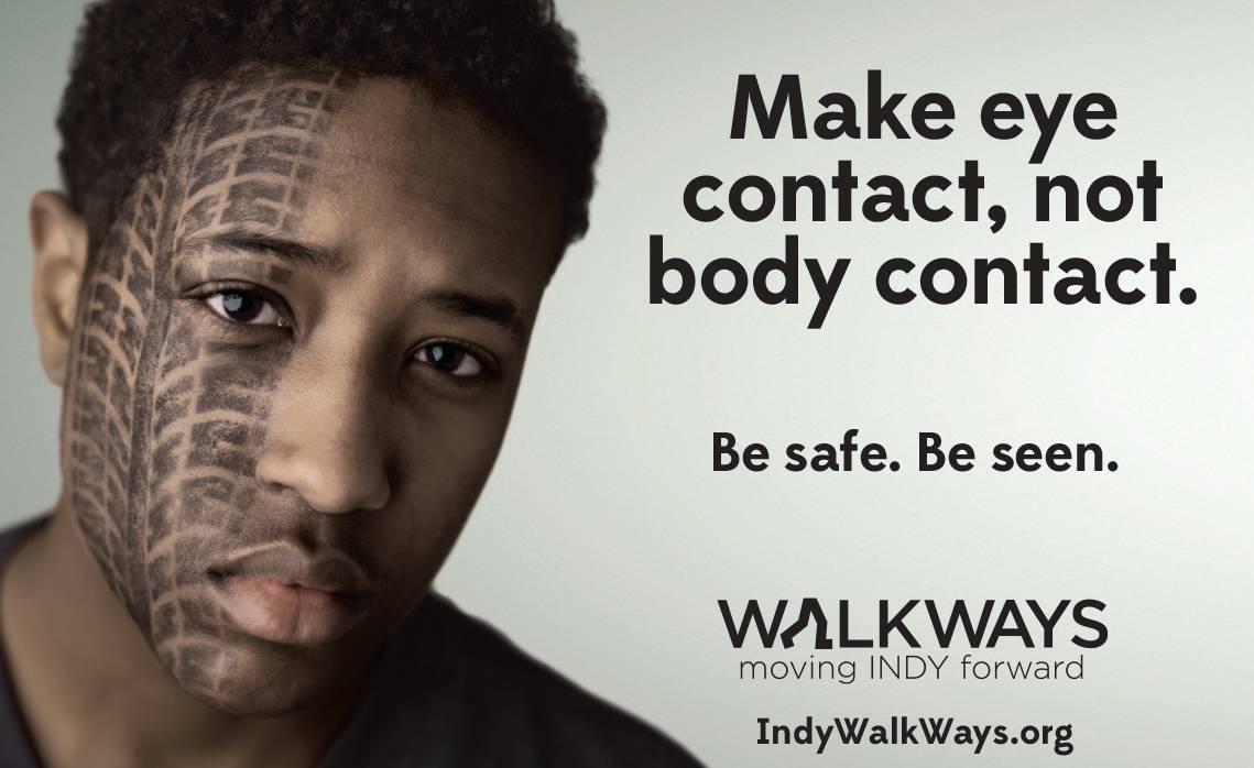
Pedestrian safety campaign
A coalition is working to make Indianapolis more pedestrian-friendly. A new safety education campaign was unveiled Tuesday in one of Marion County’s most dangerous areas for walkers -- at the intersection of 34th Street and Moeller Road.
WalkWays is a partnership of Health by Design, the City of Indianapolis and the Marion County Public Health Department. The campaign includes ads on IndyGo buses, yard signs and social media graphics.
Last year, WalkWays released the results of a study that analyzed more than 1100 car-pedestrian crashes in Marion County that occurred between 2010 and 2014. The study identified the 10 worst areas for pedestrian safety outside of downtown. During that time, at least 75 pedestrians died as a result of being hit by vehicles.
The study of pedestrian crashes in Marion County continued; and for 2015, Indianapolis Emergency Medical Services records were used along with police reports, allowing for further analysis. There was a significant increase in pedestrian crashes in 2015. Thirty people were killed while walking last year, a number that accounted for 35 percent of all traffic fatalities in the county. Nearly 20 percent were hit-and-runs, and nearly 20 percent occurred downtown. As in past years, most crashes occurred during day-light hours, in dry and clear conditions. November was the month with the highest number of crashes last year.
Twelve of the city’s pedestrian safety zones are:
- Downtown Indianapolis
- Meridian and Illinois streets from 14th to 34th streets, including extended portions of 16th, 28th, 29th, 30th and 32nd streets
- East 38th Street from the State Fairgrounds to Sherman Avenue
- West 34th and 38th streets, from Moller Road west to I-465, including portions of High School and Moller roads
- Dr. Martin Luther King Jr. Street from 25th to 30th streets
- East 10th Street from Woodruff Place to Arlington Avenue
- West 10th Street from Tibbs Avenue to Dr. Martin Luther King Jr. Street
- East Washington Street from Willard Park to Arlington Avenue, including portions of Michigan, New York and Rural streets and Emerson Avenue
- West 38th Street between Boulevard Place and Meridian Street
- West Washington Street from 465 to Holt Road, including portions of Oliver Avenue and Morris Street
- Areas near Fountain Square and Garfield Park, including extended portions of Madison Avenue, East, Shelby, Morris and Raymond streets
- Areas near Washington Park and Douglas Park/Golf Course, including extended portions of 25th and 30th Streets and Keystone Avenue
One of WalkWays’ many community partners is the International Marketplace Coalition.
“The International Marketplace is vibrant and diverse, and we are recognized as a thriving cultural, commercial and connected destination within Indianapolis.” said Mary G. Clark, executive director of the International Marketplace Coalition. “Unfortunately, our part of the city also has a very high rate of pedestrian crashes. We want to provide the safest community possible for our residents and visitors, so our coalition is a committed partner in the WalkWays initiative."
Clark said the pedestrian safety education campaign will help to raise awareness and remind everyone need to stay alert and pay attention.
To download and use WalkWays’ Tired Faces materials, visit www.indywalkways.org/safety.

 Support WFYI. We can't do it without you.