 DONATE

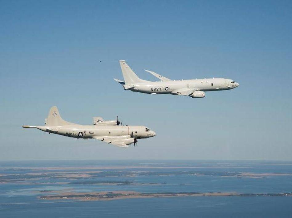
Australian P-3 Orions and U.S. P-8A Poseidons, the two aircraft at the heart of a search for possible wreckage from Malaysia Airlines Flight MH370 in the middle of the Indian Ocean, are equipped with sophisticated radar and other sensors to detect debris.
But weather, the sheer distance to the target area, about 1,500 miles off of Australia's west coast, is already complicating efforts to answer the question of just what's out there. Because of ocean currents, the search area has also expanded since the possible wreckage was photographed on March 16. And, it could already be on the bottom of an ocean thousands of feet deep.
It's also the first "credible lead" in days in what is the largest search and rescue (SAR) mission in history, involving assets from more than two dozen countries.
How Far Can They Fly?
Both the P-3 and the P-8 have the range – but only just — to get to the general search area, spend a few hours looking, and return. The P-3 has a range of 1,500 miles with three hours on station and the P-8, a modified Boeing 737, can fly out about 1,400 miles and spend about four hours searching before having to turn back.
The P-8's AN/APY-10 radar, designed to locate enemy surface contacts such as submarine periscopes, and the Australian P-3's somewhat less sophisticated radar set, would likely be the first to pick up on any floating refuge, says Sam LaGrone, editor at U.S. Naval Institute (USNI) News and a former maritime reporter for Jane's Defence Weekly.
"It's not like looking out the window," he says.
How Would They Spot Any Wreckage?
Once a radar contact is made, typically from a fairly high altitude, the plane can dip down to get a closer look, switching on an EO/IR (electro-optical/infrared) ball housed under the aircraft. These are similar to the pods you might see hanging under a police helicopter, LaGrone says.
"Pretty much all military radar are built to filter out ocean spray, rain, clouds and all other manner of potential interference via different frequencies and different methods," he says.
The EO/IR unit, though, blends high-tech camera images with infrared input into a "very detailed convential video image" similar to what military reconnaissance and strike drones use. Darkness limits the effectiveness of the cameras and the debris, now nearly as cold as the surrounding ocean, also means limited infrared input.
"Maybe [the wreckage is] down on the bottom, maybe it's floated away," he says. "If it's on the surface, the radar would be able to detect it relatively easily."
What If The Debris Has Already Sunk?
LaGrone says both aircraft are capable of dropping sonobuoys, which are designed to detect submarines, but they might not be of much use for an object sitting on the bottom of the ocean. You can see a video of a P-3 dropping a sonobuoy here.
"If it's underwater, you might be able to detect that with sonar, but it really depends on the circumstances," he says.
"If you determined there was something there – either on the surface or on the bottom – that's when surface ships would arrive with more sophisticated sonar and underwater equipment to take a closer look," LaGrone says.
In a nine-hour search on Thursday of the area where the satellite spotted possible debris, a U.S. P-8 came back empty-handed after finding only a freighter and some dolphins, ABCNews says.
According to ABC:
"The plane worked back and forth through its search area in a lawn mowing pattern. ... The Poseidon had enough fuel to scan for three hours and cover 4,100 square miles before having to begin the three hour trip back to its base north of Perth, Australia. The crew was disappointed that it hadn't found anything."
The Telegraph says a merchant ship was also diverted to the area, but apparently found nothing either.
The Australian Maritime Authority says a C-130 Hercules has been dispatched to the area "to drop marker buoys to assist with the search and indicate water movements," the newspaper says, adding that "Commercial satellites have been redirected to capture further images from the area."
9(MDEwMDc1MzM3MDEzNDczOTA0MDc1MzViMQ001))


 Support WFYI. We can't do it without you.